
Food & Climate
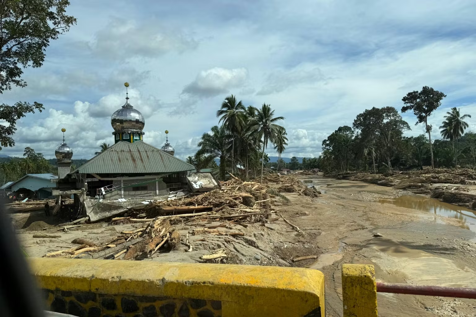
Decades of deforestation in Sumatra, also mining, plantations, and peat drainage left watersheds unable to absorb intense rainfall, turning extreme weather into a mass-casualty disaster.
Sumatra is an island in western Indonesia, one of the largest islands in the world and the largest island entirely within Indonesian territory. It overlooks the Indian Ocean and is separated from the Malay Peninsula and Malaysia by straits. The equator is located almost in the middle of it, giving it a hot and humid tropical climate.
The deforestation in Sumatra caused loosing millions of hectares of forest since 2001, increasing runoff, destabilizing slopes, and amplifying floods and landslides when heavy rain hits.
Peatland drainage has created a hidden, compounding flood risk. Canals dug for plantations dry and compact peat soils, causing land subsidence and transforming once water-retentive landscapes into low-lying areas prone to chronic inland and coastal flooding.
Urban expansion into floodplains and degraded catchments means that even rare storms now endanger more people and infrastructure, locking much of Sumatra into a cycle of disaster unless land-use governance changes, according to a report seen by Food & climate.
Call to stop deforestation in Sumatra and all Indonesia
Indonesia’s government has been at pains to stress that the recent catastrophe in Sumatra was triggered by a rare meteorological event. Cyclone Senyar formed in the Malacca Strait, an area where the national weather agency notes such storms are “an extremely rare phenomenon,” before unloading torrents of rain on Aceh, North Sumatra and West Sumatra.
Meteorologists say the interaction of two cyclones may have produced record rainfall over parts of the island. Scientists are cautious about pinning any single storm on climate change.
Officials themselves have begun to say the quiet part out loud. Forestry minister Raja Juli Antoni told parliament that “poor forest management” had worsened the disaster, and promised to “review forest governance, consider a moratorium on new permits, and revoke the licenses of violators,” according to Reuters.

The environment minister, Hanif Faisol Nurofiq, has suspended permits for several companies in the Batang Toru watershed and warned that criminal proceedings are possible if violations are found. Sumatra has lost an estimated 4.4 million hectares of forest since 2001. The Indonesian Forum for the Environment (WALHI) estimates that 1.4 million hectares of forest in Aceh, North Sumatra and West Sumatra were cleared between 2016 and 2025 alone, much of it for mining, palm oil and pulpwood.
Floodwaters recede
When the floodwaters receded, viral images showed how extensive clearing shapes disaster impacts on the ground: houses smashed by logs, riverbanks lined with cut timber, and whole slopes stripped to bare soil.
Cyclone Senyar was an unusually rare event for Sumatra, but the scale of destruction cannot be explained by weather alone.
The floods underscore that decades of deforestation in Sumatra, peat drainage and poor land-use management have created systemic, predictable risks. Restoring forests and peatlands and enforcing spatial plans will not prevent rare cyclones — but without such reforms, the next unusual storm could again become a wholly avoidable catastrophe.
“The disaster was not just nature’s fury, it was amplified by decades of deforestation,” WALHI’s Rianda Purba told the Associated Press. The Batang Toru catchment, one of the worst-hit areas, now hosts hydropower schemes, a major gold mine, and plantations in what was once a continuous upland rainforest.

The physical mechanisms are well understood. Intact forests slow rainfall, hold soil in place and allow water to percolate into the ground rather than roar off the surface. When forest is replaced by roads, pits, and monoculture estates, that sponge function fails.
Analysts writing in The Conversation describe how, in degraded catchments, “the ecosystem loses its natural ability to act as a ‘sponge,’” so intense rain turns quickly into destructive runoff and unstable slopes. That pattern was stark in the western block of Batang Toru, where satellite images show thousands of hectares of forest converted, then gouged away by landslides during the storm, according to “Mongabay“.